Placer and Stream Deposits
Read alluvium, point bars, terraces, bedrock traps, false bedrock, and pay streaks using stream energy.
By the end of this module
- Predict where heavy minerals settle
- Identify modern and abandoned channels
- Design an efficient test-pan pattern
You’re standing on a wide gravel bar where Clear Creek bends hard to the left. The water’s moving fast on the outside of that bend and noticeably slower on the inside. If you only have an hour before you need to head back to the trailhead, where do you dig? This module gives you the actual physics behind that decision, plus the Colorado-specific terrain where it’s played out for over 165 years.
Alluvium — The Basic Building Block
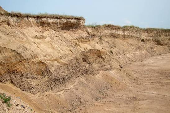
Alluvium is sediment deposited by flowing water — the general term for stream-transported and sorted gravel, sand, and silt. Every placer deposit you’ll ever work is some flavor of alluvium, whether it’s sitting in the active channel today or perched on a terrace far above the modern stream.
Terraces — Old Streambeds Hiding in Plain Sight
Terraces (sometimes called “bench” deposits) are old, elevated floodplain or streambed remnants left behind as a stream cuts down into its valley over time. What was once the active channel and floodplain can end up sitting 10, 50, or hundreds of feet above the modern creek — still holding whatever gold it originally concentrated, now largely disconnected from today’s water.
Terrace gravels along Colorado’s South Platte, Arkansas, and Colorado Rivers, and along Clear Creek, San Miguel, and Dolores Rivers, have all historically produced placer gold (Colorado Geological Survey — Metals; placer gold in southwestern Colorado, New Mexico Geological Society). If you’re only searching the active channel and ignoring bench gravels above it, you may be walking past ground that was rich enough to mine a century ago.
Where Gold Actually Settles: Point Bars, Bedrock Traps, and Pay Streaks
Point bars
Point bars form on the inside of stream meander bends, where flow velocity drops as the channel curves. Slower water can’t carry as much sediment, so material — including dense gold — drops out. This is the classic, most-cited target in placer literature, and it’s the direct answer to the scenario that opened this module: the inside of that bend, not the fast outside edge, is where you’d want to sample first (Oregon Gold Hunters guide).
Bedrock traps
Bedrock traps are irregularities, cracks, crevices, and rough surfaces in the true bedrock underlying a placer deposit. Gold cannot sink any further once it reaches solid rock, so it accumulates wherever that rock surface catches it. Rock type matters:
| Bedrock type | Gold-trapping quality |
|---|---|
| Jointed/fissured rock dipping steeply | Good — catches and holds particles |
| Decomposed granite | Good — soft, irregular surface |
| Compact clay or clayey volcanic tuff | Good — acts as an effective “gold saver” |
| Smooth, hard rock (e.g., serpentine) | Poor — nothing for gold to catch on |
(911Metallurgist Placer Gold Geology reference)
False bedrock
A false bedrock is a hard layer — commonly clay, hardpan, caliche, or an ancient volcanic tuff bed — sitting well above the true bedrock that mimics real bedrock’s gold-trapping behavior. Gold can accumulate on top of a false bedrock layer exactly as it would on the genuine article, and prospectors sometimes stop digging there, missing additional gold sitting on the true bedrock below (alaskaweb.org mining glossary; RareGoldNuggets.com). If Module 3’s caliche discussion rang a bell here, that’s exactly the connection — run the acid test on any hard layer you hit before you decide you’ve reached bottom.
Pay streaks
A pay streak is a limited, often narrow and sinuous horizon within a placer deposit that holds a rich enough concentration of gold to be worth mining. Pay streaks don’t necessarily follow the present-day stream channel — they can split, pinch out, or terminate abruptly, because their location was dictated by paleo-channel controls that may no longer be visible on today’s surface (USGS Bulletin 1857, "Gold in Placer Deposits"; 911Metallurgist Placer Examination). This is exactly why a single “hot” pan doesn’t tell you the shape or extent of what you’ve found — see the sampling pattern in the field exercise below.
Colorado Ground Truth
- Colorado’s first documented gold discovery, in 1858, was placer gold found at the confluence of Cherry Creek and the South Platte River — Auraria, now downtown Denver (Colorado Geological Survey — Metals).
- Clear Creek, the South Platte River, and the Arkansas and Colorado Rivers still yield small amounts of placer gold today, largely as a byproduct of commercial sand-and-gravel aggregate operations (Colorado Geological Survey — Metals).
- Historic districts including Breckenridge, the Leadville area, Alma-Fairplay, and North Clear Creek are all well documented as major historic placer producers. Exact historic production totals for these districts vary between sources, so this course won’t quote specific ounce figures — if you want production numbers for a specific district, cross-check a Colorado Geological Survey or USGS district report directly rather than relying on any single secondary compilation.
- Clear Creek and North Clear Creek, in Clear Creek and Gilpin Counties, remain the most consistently referenced public placer-panning locations in current recreational-prospecting literature.
Building a Sampling Pattern from Stream Energy
Put the pieces together and you get a simple decision framework:
- Look at the channel shape. Meander bends mean point bars on the inside curve — sample there first.
- Look for terraces above the active channel. Old benches can hold gold the modern stream never touches.
- Dig to true bedrock where practical, and treat any hard layer you hit along the way as a possible false bedrock — test it, don’t assume it.
- Don’t stop at one good pan. A single rich sample tells you a pay streak might be nearby, not where it starts or ends. Sample across the width and depth of the deposit before drawing conclusions.
Myth Check: “False Bedrock” Fools More People Than You’d Think
The most persistent myth in this module isn’t about gold’s appearance — it’s about knowing when to stop digging. A hard clay or caliche layer that fizzes with acid and looks and feels like bedrock is not necessarily the bottom of the deposit. Real bedrock, in most Colorado alluvial settings, is markedly harder, often fractured or jointed rock rather than a cemented sediment layer. When in doubt, dig a little further or examine the material’s composition rather than assuming a stopping point.
Common Mistakes
- Sampling only the fastest-looking water. Fast water carries sediment through, it doesn’t drop it — slower water on the inside of bends is where deposition happens.
- Ignoring terraces entirely. Bench gravels well above the current stream can be productive and are frequently overlooked by people fixated on the active channel.
- Stopping at the first hard layer. Test it before assuming it’s true bedrock (see Module 3’s acid test).
- Treating one hot pan as proof of a pay streak’s extent. Pay streaks are narrow and can be discontinuous — a single sample only tells you gold is present somewhere nearby.
- Quoting exact historic production numbers as settled fact. As noted above, older secondary sources disagree; treat specific figures skeptically unless sourced to a primary CGS/USGS district report.
Field Exercise
Pick a stretch of stream you’re legally permitted to sample (see Module 8 before you dig anywhere). Sketch the channel from above — mark meander bends, visible terraces, and any exposed bedrock. Then plan a sampling grid:
| Sample # | Location type (point bar / terrace / mid-channel / near bedrock exposure) | Depth reached | Result (color count or notes) |
|---|---|---|---|
| 1 | |||
| 2 | |||
| 3 | |||
| 4 |
Take at least four samples across different channel positions before drawing any conclusion about the site’s potential — one good pan is a data point, not a verdict.
Sources and Further Reading
- Colorado Geological Survey — Metals
- USGS Bulletin 1857 — Gold in Placer Deposits
- New Mexico Geological Society — Placer gold in southwestern Colorado
- Oregon Gold Hunters — How to Read Placer Deposits
- 911Metallurgist — Placer Gold Geology
- alaskaweb.org mining glossary
- RareGoldNuggets.com — false bedrock