Maps, Claims, and Legal Access
Combine topographic and geologic maps with land ownership and current claim records before entering the field.
By the end of this module
- Read USGS and CGS maps together
- Check ownership and active claims
- Know when Casual Use no longer applies
You’ve found a promising stretch of gravel using everything from Modules 1 through 7. Before you touch a shovel to it, answer the one question no field test can answer: are you allowed to dig here? This is the one place in this course where getting it wrong costs more than a wasted afternoon.
The Current System: BLM MLRS Has Replaced LR2000
As of 2026, the BLM Mineral & Land Records System (MLRS) has replaced LR2000 as the official system for case management and land status records, including Master Title Plats and Tract Books. LR2000 case management was last deployed in June 2023 and has since been succeeded by MLRS; the Alaska Land Information System was separately replaced by MLRS Release R4 in October 2024. One remaining gap: the LR2000 “Historical Index” has not yet migrated into MLRS and is scheduled for a future release, so historical claim research may still need legacy tools or direct agency assistance. MLRS reports also carry Privacy Act redactions; unredacted reports require a Login.gov account (BLM Mineral & Land Records System Reports). If you see older material referring to “LR2000,” treat that as legacy language for the same underlying BLM claims data, now served through MLRS.
USGS Topographic Maps — Your Terrain and Survey Reference
Standard 1:24,000-scale ("7.5-minute") USGS topo quadrangles are the core tool for terrain, drainage, and legal-survey reference. Key symbol categories:
| Symbol category | Color/appearance | What it tells you |
|---|---|---|
| Contour lines | Brown | Elevation and slope |
| Hydrography | Blue | Streams, lakes, wetlands |
| PLSS grid | Black lines/labels | Township/range/section — the same grid BLM’s claims data uses |
| Mines and Caves symbols | Dedicated symbol set | Open-pit mine, borrow pit, tunnel/cave entrance, shaft, prospect, tailings, mine dump |
(USGS Topographic Map Symbols)
The Mines and Caves symbols flag historic disturbance directly on the map, a cross-check against Module 6’s field assessment, and the PLSS grid is the same reference system BLM’s claims database uses — a topo map and MLRS/MyLandMatters are directly cross-referenceable.
Colorado Geological Survey Geologic Maps
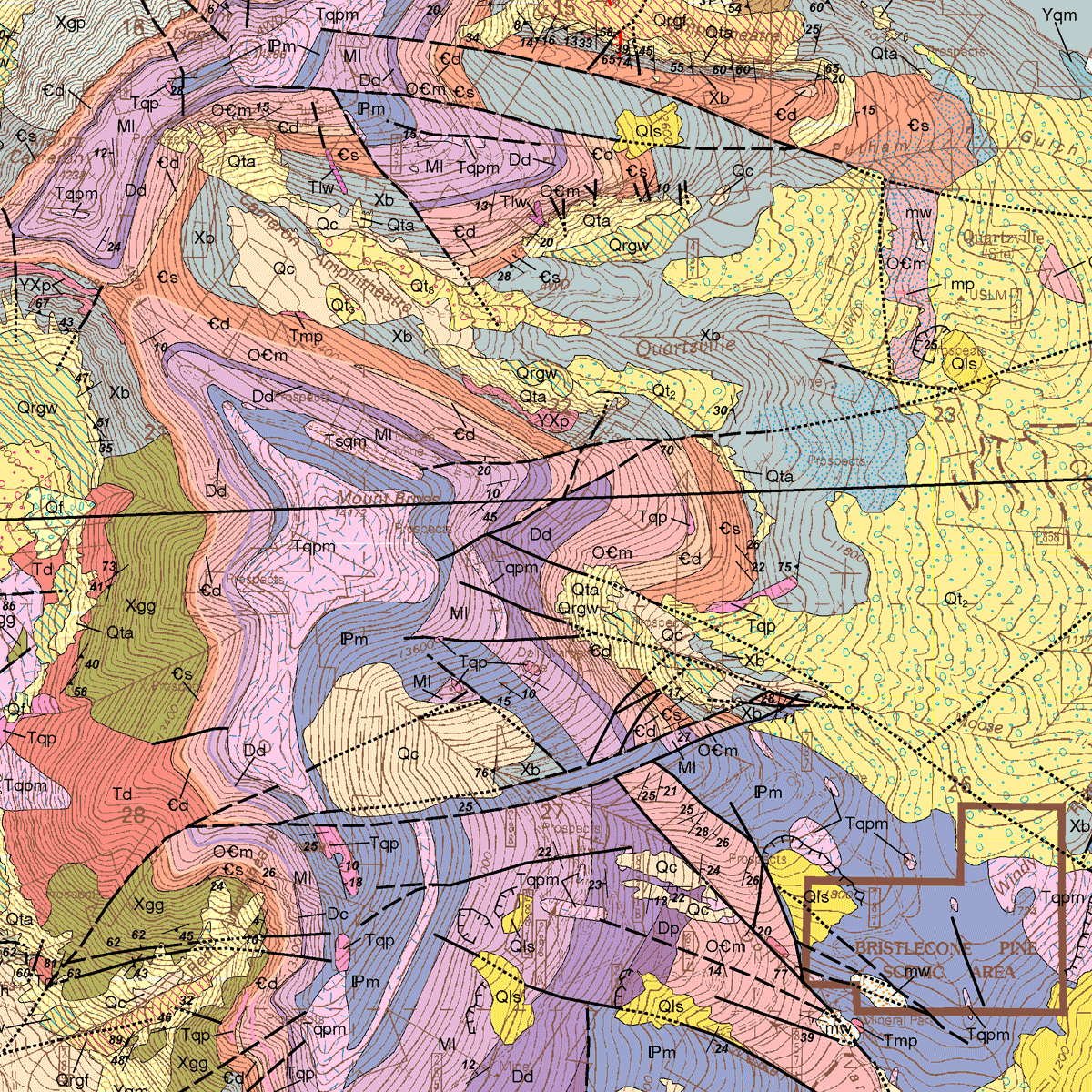
The Colorado Geological Survey (CGS), housed at Colorado School of Mines in Golden, maintains a GIS Data and Web Map Portal with STATEMAP-funded 1:24,000 geologic quadrangle maps (PDF plates plus GIS packages), an interactive map viewer, and a STATEMAP Progression Map tracking which quadrangles have been geologically mapped statewide (CGS GIS Data and Web Map Portal; CGS Geologic Mapping page; STATEMAP Progression Map). These maps show rock units, structure, and surficial deposits — the essential complement to a topo map for understanding what’s on and under the ground. CGS can be contacted directly: 1801 Moly Road, Golden, CO 80401, (303) 384-2655 (CGS RockTalk newsletter contact info).
BLM MLRS for Claim Status — Know the Limitations
MLRS is the authoritative source for active and closed unpatented mining claim status, but it has real limitations. BLM does not maintain a simple public list of “land open for mining claims” — you must determine both whether land is open to mineral entry and whether it’s already claimed (BLM Mining Claims Packet). Filing a claim doesn’t make it valid on its own — validity requires a genuine mineral discovery, proper staking, and recordation with both BLM and the county within 90 days, or the claim is void by law. BLM won’t adjudicate disputes between competing claimants ("overstaking"). And patented ground is invisible to BLM claims data: many historically productive Colorado placer streams sit on patented land and aren’t open to public prospecting regardless of what the unpatented-claims database shows.
Third-Party Tools Are Research Aids — Not Legal Records
This is the most common way prospectors get into trouble, so treat both tools below strictly as starting points.
MyLandMatters.org is a free, volunteer-run tool that visualizes BLM claims data (now sourced from MLRS) as an interactive map with PLSS overlays, letting you click a section for claim details and a live link to the official BLM Serial Register report (MyLandMatters.org — Mining Claims Maps; MyLandMatters symbol/update documentation). Its own documentation admits real limits: claims layers update only twice monthly, lagging real filings by up to ~15 days, and it states, "Your due diligence is still required before making decisions about land status." Its separate historical MRDS/MAS-MILS mine-location layer reflects source reports only as current as their original publication date and does not show up-to-date mine status; roughly 4,000 records lack reliable coordinates (MyLandMatters — Mining History Claim Maps documentation).
onX and similar commercial mapping apps offer land-ownership and, in some tiers, mining-claim overlays for field navigation — commercial products, not the legal system of record. Any claim or ownership layer in onX must be independently verified against BLM MLRS, the county recorder/clerk’s office, and county assessor records before any legal or financial decision.
The Verification Workflow
One repeatable due-diligence sequence, in order:
- Identify the Township/Range/Section using a USGS topo map or PLSS layer.
- Check the CGS geologic map for likely rock and deposit types.
- Check BLM MLRS (and/or MyLandMatters as a faster first pass) for the managing agency and any active unpatented claims in that section.
- Contact the specific BLM field office or USFS ranger district to confirm current status and local restrictions.
- Visit the county clerk/recorder’s office for recent filings not yet online, and the actual claim location notice, which gives exact boundaries — section-level map data only shows a claim exists somewhere within a square mile, not its footprint (MyLandMatters workflow demonstration).
- Confirm patented versus unpatented status — patented placer ground is common along historically rich Colorado streams and isn’t open to public prospecting without landowner permission.
Skipping from “onX shows this as open” straight to digging is the most common shortcut that gets prospectors in trouble.
Casual Use — What It Actually Covers, and Where It Stops
Casual Use is not one universal rule — it’s a specific regulatory category that differs by managing agency.
On BLM land: 43 CFR
Per BLM’s 2026 Mining Claims Packet, Casual Use applies only on BLM land and means little-to-no surface disturbance:
| Included as casual use | Excluded from casual use |
|---|---|
| Hand-tool collection, hand panning, non-motorized sluicing | Mechanized earth-moving equipment |
| Metal detecting, battery-operated mineral-sensing devices | Truck-mounted drilling equipment |
| Hand/battery dry washers, small portable suction dredges* | Motorized vehicles in areas closed to off-road use |
| Motorized use consistent with travel-management/OHV designations | Chemicals, explosives |
*Suction dredges still require a state permit regardless of casual-use status. This course isn’t citing specific Colorado dredge-permit requirements — verify those directly with Colorado Division of Reclamation, Mining and Safety and Colorado Parks and Wildlife before running a dredge.
Hand-digging for rockhounding is allowed, holes must be filled, and digging deep enough to risk a cave-in is explicitly not casual use. Disturbance of 5 acres or less beyond casual use requires a Notice of Operations 15 days before starting; more than 5 acres requires a Plan of Operations.
On Forest Service land: 36 CFR § 228
On Forest Service land, the equivalent framework is 36 CFR § 228 — not BLM’s casual-use language. PSICC states plainly that hand-tool gold panning, hand sluicing, and metal detecting need no permit, but “significant surface disturbance” (36 CFR 228.4a(1)(iv)) triggers a plan requirement, and streambank digging must stay below the high-water mark without caving/undermining banks or exposing roots (USFS PSICC — Rockhounding, Prospecting, and Fossil Collecting). Treat 43 CFR and 36 CFR 228 as related but distinct — don’t assume a rule on one agency’s land applies on the other’s.
Myth Check: Casual Use Is Not a Blanket Permission Slip, and an Unpatented Claim Isn’t Private Property
Two myths, one section. First: Casual Use does not grant blanket legal permission everywhere. It applies specifically on BLM land under 43 CFR, exists as a distinct framework on Forest Service land under 36 CFR 228, doesn’t apply on patented or private land, and can be overridden locally by wilderness designations, withdrawals, existing claims, or seasonal closures. Second: an unpatented mining claim does not make the surface private property — ownership stays with the United States, the managing agency retains authority, and the public retains a conditional right to cross claims for recreation. Occupying public land under the mining laws more than 14 days per 90-day period requires bona fide, ongoing mining activity; casual camping beyond that needs an approved Plan of Operations. Always confirm current status with the specific field office or ranger district before digging.
Common Mistakes
- Calling LR2000 “the current system." It’s been replaced by MLRS, though the Historical Index gap means some historical research may still need legacy tools.
- Trusting onX or MyLandMatters as final legal proof. Both are research aids — verify against BLM MLRS and the county recorder/assessor.
- Mixing up 43 CFR and 36 CFR 228. Check which agency manages the parcel and apply the matching framework.
- Assuming an unclaimed BLM section is automatically diggable. Confirm it’s open to mineral entry, not patented, not withdrawn, not otherwise restricted.
- Skipping the county recorder step. Online tools lag real filings; only the recorder’s location notice gives a precise boundary.
Field Exercise
Before your next trip, run the verification workflow on paper for one target site:
| Step | Finding |
|---|---|
| Township/Range/Section | |
| MLRS claim status (+ MyLandMatters first pass) | |
| Managing agency contacted? | |
| County recorder checked? | |
| Patented or unpatented? | |
| Applicable framework (43 CFR / 36 CFR 228 / private) |
Only mark a site “cleared to prospect” once every row has a real answer, not a guess.
Sources and Further Reading
- BLM Mineral & Land Records System Reports (official status page)
- BLM Mining Claims Packet, March 2026
- USFS PSICC — Rockhounding, Prospecting, and Fossil Collecting
- USGS Topographic Map Symbols
- Colorado Geological Survey GIS Data and Web Map Portal
- CGS Geologic Mapping page
- STATEMAP Progression Map
- CGS RockTalk newsletter contact info
- MyLandMatters.org Mining Claims Maps
- MyLandMatters symbol/update documentation
- MyLandMatters Mining History Claim Maps documentation
- MyLandMatters user demonstration of the due-diligence workflow