Glacial Till, Moraines, and Outwash
Learn how ice moved Colorado rock, how till differs from outwash, and why sorting and rounding matter.
By the end of this module
- Identify unsorted till
- Recognize outwash and glacial terraces
- Avoid mistaking transported boulders for local bedrock
You’re above 10,500 feet in a broad, U-shaped valley in the Sawatch Range, standing next to a ridge of jumbled boulders and clay that clearly doesn’t belong where it sits. Someone in your prospecting group calls it “glacial till” with total confidence. Maybe it is. But it could just as easily be talus that rolled off the headwall last spring, or colluvium that’s been creeping downslope for ten thousand years. Telling these apart isn’t academic trivia — it directly determines whether the gravel in front of you is worth a test pan.
Five Deposit Types, One Skill: Reading Sorting and Roundness
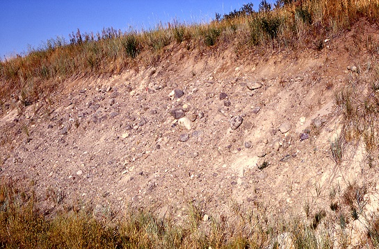
Colorado’s high country is full of coarse, bouldery material, and beginners lump most of it together as “glacial junk.” In reality there are at least five distinct deposit types you’ll run into, and they behave very differently as prospecting targets. The single most useful skill in this module is learning to read sorting (are the grain sizes mixed together or separated into similar-size groups?) and roundness (are the edges sharp and angular, or worn smooth and rounded?).
| Deposit type | Transport mechanism | Sorting | Clast shape | Prospecting value |
|---|---|---|---|---|
| Till | Deposited directly by glacial ice | Unsorted — clay to boulders together | Angular to subangular | Generally poor — never water-concentrated |
| Outwash / glaciofluvial | Glacial meltwater streams beyond the ice margin | Sorted, stratified | Rounded | Good — can host reworked placer gold |
| Talus | Rockfall/freeze-thaw off a cliff or headwall | Unsorted, but often more uniform in rock type | Angular | Generally poor — no water sorting, single local source |
| Colluvium | Slow gravity creep to rapid slope failure | Unsorted, mixed rock types | Angular | Poor as a direct target, but can carry mineral clues from an unknown upslope source (see Module 3) |
| Debris flow | Rapid, water-saturated slurry moving downslope | Poorly sorted, often matrix-rich | Angular to subangular, sometimes with rounded clasts entrained | Poor to unpredictable — mixed transport history |
Till and Moraines
Till is sediment deposited directly by glacial ice — an unsorted mixture of everything from clay to boulder-size material, with angular to subangular clasts because the transport was short and direct, riding in or on the ice without water sorting it along the way.
A moraine is a ridge or mound of till marking the former margin or extent of a glacier — terminal (at the glacier’s farthest downstream extent), lateral (along its sides), or recessional (marking a pause during retreat).
Field rule of thumb: till = unsorted + angular.
Outwash and Glaciofluvial Deposits
Outwash (also called glaciofluvial deposits) is sediment transported and deposited by glacial meltwater streams beyond the ice margin. Because water did the sorting, outwash is stratified and sorted, with rounded clasts — it looks and behaves much like ordinary stream alluvium, because functionally, that’s what it is.
Field rule of thumb: outwash = sorted + rounded, and it’s essentially interchangeable with alluvium for prospecting purposes once you’re past the ice margin.
Colorado High-Country Context
Colorado’s peaks above roughly 9,500–10,000 feet preserve classic alpine glacial landforms from Pleistocene glaciation: cirques (bowl-shaped basins carved at valley heads), U-shaped valleys (as opposed to the V-shaped profile of a stream-cut valley), and moraines. These are well documented in areas such as Rocky Mountain National Park in the Front Range and the Sawatch Range.
Historical accounts describe gold-bearing “glacial outwash gravels” southeast of Fairplay in South Park — worth noting, though that specific reference comes from a secondary, non-official prospecting compilation rather than a USGS or CGS publication, so treat it as a lead to verify locally rather than a confirmed fact (iowagold.com Colorado placer compilation).
The practical logic holds regardless of that specific example: because till was never water-concentrated, it’s generally a poor placer target. Sorted glaciofluvial outwash, and especially post-glacial stream reworking of that outwash, are the more prospectable settings — the water sorting that built the outwash is the same physical process (density-based concentration) that builds any placer deposit.
Don’t Skip Talus, Colluvium, and Debris Flow
It’s easy to see any bouldery high-country slope and default to “till.” Three other processes produce similar-looking piles of coarse rock, and confusing them wastes time:
- Talus accumulates below cliffs and headwalls from repeated rockfall, often driven by freeze-thaw cycling. It tends to be more uniform in rock type than till (because it’s sourced from one nearby cliff face) and shows no relationship to a moraine ridge or U-shaped valley — it just sits at the base of steep terrain at the angle of repose.
- Colluvium (covered in Module 3) creeps or slides downslope under gravity and mixes rock types from wherever it traveled — angular, unsorted, and thickening downslope.
- Debris flows are rapid, water-saturated slurries that move suddenly downslope, often triggered by intense rain or rapid snowmelt. They’re poorly sorted like till, but their matrix is often richer in fine sediment because water was actively mixed into the moving mass, and they follow drainages/gullies rather than sitting as a ridge.
Myth Check: Not All Bouldery High-Country Material Is “Glacial Till”
This is the core myth this module exists to correct. Plenty of similar-looking coarse, angular deposits in the high country are talus, rockfall, or colluvium from periglacial (freeze-thaw) processes — not ice-transported material at all. Texture alone (a jumbled pile of angular boulders) is not enough to call something till.
Two better diagnostic clues:
- Position — is the deposit associated with a lateral or terminal moraine ridge and a U-shaped valley? If you’re on a valley wall with no ridge form and no U-shaped cross-section, you’re probably not looking at till.
- Clast mix — does the deposit include far-traveled “erratic” rock types that don’t match any bedrock upslope in that specific drainage? True till often carries erratics that ice dragged from a different source area; talus and colluvium are almost always locally sourced from the slope directly above.
Common Mistakes
- Calling every bouldery high-country deposit “till” by default. Check position and clast mix before you commit to that label.
- Panning straight till and expecting concentrated gold. Till was never water-sorted — any gold present is exactly as scattered as it was when the ice dropped it, with no natural concentration process at work.
- Ignoring outwash terraces below the moraine. These sorted, rounded gravels are a far better prospecting target than the till itself, and they’re often just downstream.
- Assuming a moraine-shaped ridge always means till. Confirm with clast angularity and mix — a ridge-like landform can occasionally result from other slope processes too.
Field Exercise
Locate a high-country site with visible coarse debris — a valley wall, a ridge, or a stream cut through older gravel. For the deposit in front of you, record:
| Observation | Your notes |
|---|---|
| Sorted or unsorted? | |
| Clast shape (angular / subangular / rounded)? | |
| Position relative to a moraine ridge or U-shaped valley? | |
| Any erratic rock types not matching local upslope bedrock? | |
| Best-guess classification (till / outwash / talus / colluvium / debris flow) | |
| Would you test-pan this material? Why or why not? |
Sources and Further Reading
- General glacial sediment definitions (till = unsorted/angular; outwash = sorted/rounded) as corroborated across standard geomorphology and NRCS/USGS soil and surficial-geology terminology.
- iowagold.com — Colorado placer gold compilation (a secondary, non-official compilation — verify any specific site claims locally before relying on them)
A note on sourcing: this module currently relies on general glacial-geomorphology principles rather than a single dedicated USGS or Colorado Geological Survey publication specific to Colorado’s alpine glacial deposits. If you want to go deeper on Colorado-specific glacial mapping, search the CGS publications catalog and USGS Professional Papers covering Colorado Quaternary geology and Rocky Mountain National Park glacial history.